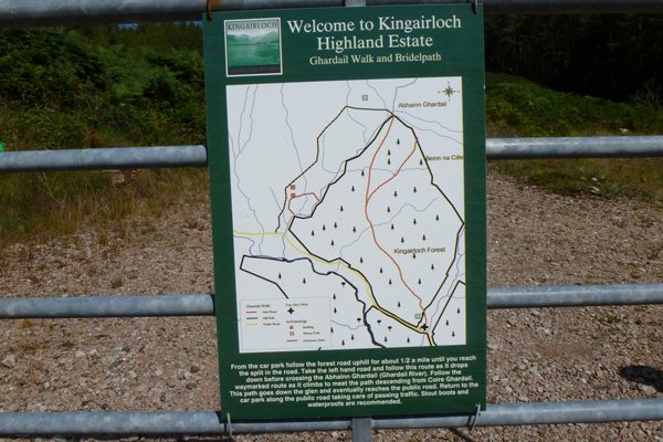
Wild About Lochaber

Wild About Lochaber

where great adventures begin...

Search form

Menu

  • Home
  • Explore
    • Wild Lochaber
    • Ardnamurchan, Moidart & Morvern
    • Fort William and Glen Nevis
    • Glencoe and Loch Leven
    • The Road To The Isles
    • #WildLochaber Photo Gallery
  • Accommodation
    • Self Catering
    • Caravan & Campsites
    • Hotels and B&Bs
  • Walking
    • Map of All Walks
    • Ardnamurchan and Moidart
    • Arisaig Mallaig and Glenfinnan
    • Fort William and Glen Nevis
    • Glencoe, Loch Leven & Argyll
  • Wildlife
    • Map of Wildlife Sites
    • Wildlife Experiences
    • Wildlife Habitats
  • Things To Do
    • Activity Providers
    • Beaches
    • Castles
    • Destinations
    • Gardens
    • Geology
    • Geopark Rock Route
    • Historic Attractions
    • Museums and Interpretation
    • Railways
    • Wildlife Experiences
    • Wildlife Hotspots
  • Travel
    • Electric Vehicle Charging Points
    • Ferries
    • Petrol Stations
    • The Caledonian Sleeper
  • What's On
    • Calendar
    • Arts, Culture and Community Events
    • Family Friendly Events
    • Walking Events
    • Wildlife & Geology Events
    • Events on Discover Glencoe
    • Road to The Isles & Ardnamurchan
  • Blogs
    • Ardnamurchan Area Blogs
    • Glencoe Area Blogs
    • Lochaber Blogs
    • West Coast Island Blogs
    • Wild About Lochaber Blog

Ghardail Loop

  • Abhainn Ghardail just above the hydro intake
  • The Ghardail Walk is on the Kingairloch Estate
  • Abhainn Ghardail (River Ghardail) at the end of the detour path
  • The walk includes a pleasant stretch along the quiet B8043
  • The track at the start of the walk from the carpark
  • The first section of the walk is through forestry plantation
  • Looking back toward the hills of Morvern
  • Crossing Abhainn Ghardail (River Ghardail)
  • Great views of the hills on a fine day
  • The Path down to the B8043 is well signed

Details

A pleasant walk through coniferous plantation and into the hills around Kingairloch.  The walk passes by some unroofed sheiling huts and an abandoned settlement.

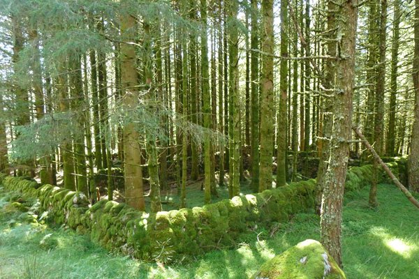
Larch, pine and spruce plantation support an understory of bryophytes, including Common Tamarisk-moss(Thuidium tamariscinum) and Sphagnum and  Polytrichum species.  Wood sorrel (Oxalis acetosella), St John's worts (Hypericum spp), tormentil (Potentilla erecta), heather (Calluna vulgaris), bell heather (Erica cinerea), violets (Viola spp) and patches of foxgloves (Digitalis purpurea) brighten the edges of the plantation in Spring and Summer.  

Ideal microclimates are also afforded for mosses and liverworts by the numerous small watercourses on route that traverse sections of the plantations.     

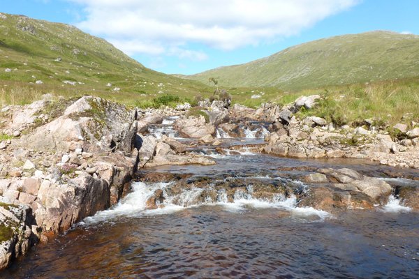
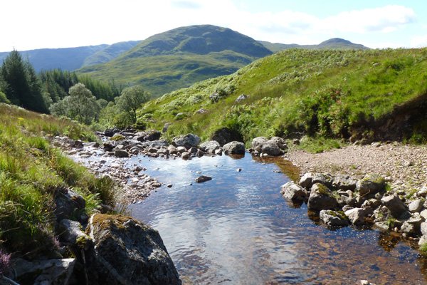
Look out for raptors in the hills, ‘conifer specialists in the plantations’ and dippers and otters in the boulder strewn River Ghardail, as well as for the tracks and signs of pine marten. 

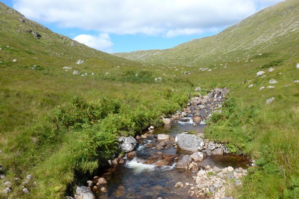
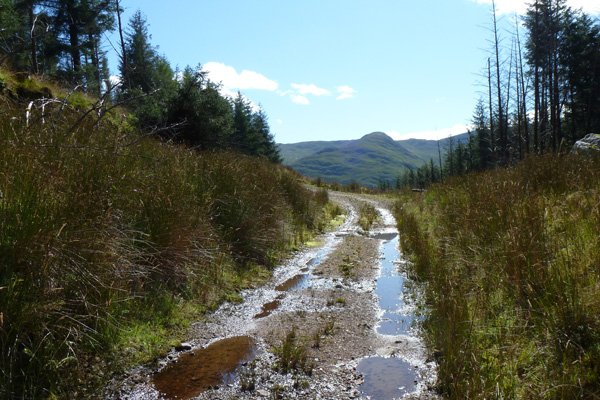
The route includes some open heath section affording lovely views of the surrounding hills.  The heath flora is variously hued through the season with purple moor grass (Molina caerulea), heather (Calluna vulgaris), bell heathers (Erica tetralix and E. cinerea), bog myrtle (Myrica gale) and bog asphodel (Narthecium ossifragum) and devil’s-bit scabious (Succisa pratensis).

Route Details

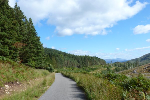
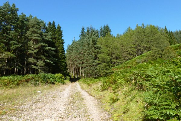
1. Park in the car park and take the track ascending into the plantation.  The track ascends steeply at first through larch, pine and spruce plantation, some of which emerge evocatively from within stone-walled enclosures.  The path also abuts open heath on occasion.

2. Where the track diverges, take the left path, which descends at first. 

3. When the path diverges by the river Ghardail, take the right path leading to the wooden bridge and head towards the hydro-electric power station. The other path leads to a ford across the river. 

4. Take the left path just before you reach (south of) the hydroelectric power station which heads across a lovely section of heath. 

5. At the junction and signpost, either turn left to continue down the hill on the Ghardail loop, or take a short detour to the Ghardail waterfall. 

If taking the detour follows the track, crossing a wooden bridge on route until the track ends at another wood bridge overlooking a series of small waterfalls.  Take time to enjoy the lovely views on route.    Return by the same route. 

The Ghardail loop heads down hill along the track. 

6. At the road, turn left and follows the road back to the car park.  The road follows the river, Abhainnna Coinnich and is fringed by heath and plantation.

Location

starting grid ref: 

NM837535

Links to useful information

  • Kingairloch Hydro Project (pdf)
  • RCAHMS- Abhainn Ghardail


grade: 

  • moderate

terrain: 

track and path

length: 

4km or 5.75 km (2.5 or 3.6miles)

Type: 

  • circular

Map: 

OS Explorer 383 - Morvern

OS Map

>>view map in full window

Google Map

Safety

Route details and information are provided in good faith.  All walking is potentially dangerous and it is your responsibility to ensure that you are properly dressed and equipped, have a map and compass, have checked and planned your route in advance and are able to navigate effectively.  Maps displayed on these walking pages are intended as an overview of the walk and are NOT suitable for navigation.  Please follow the Scottish Outdoor Access Code and respect landowners and residents' privacy.  Always check the weather forecast and let others know if you are walking in the hills.

Walking

  • Walking Overview
  • Map of All Walks
  • Ardnamurchan and Moidart
  • Arisaig, Mallaig and Glenfinnan
  • Fort William and Glen Nevis
  • Glencoe, Loch Leven & Argyll
Booking.com

Holiday Cottages in Fort William and Lochaber

Ceithir Raithean
Ceithir Raithean

A haven for those wanting breathtaking scenery, wildlife and outdoor activities combined with spacious, tasteful, relaxing and highly specified accommodation.

Ardnamurchan Walking Pages

  • Alphabet Trail
  • Aoineadh Mor
  • Ardmolich Woodland Walk
  • Ardnastaing and Scotstown
  • Ardtornish Castle
  • Ariundle Oakwoods
  • Bay MacNeil Beach
  • Bay of Flies
  • Ben Hiant
  • Ben Resipole
  • Blain Burn Circular
  • Bourblaige Cleared Settlement
  • Camas nan Geall
  • Castle Tioram Circular
  • Castle Tioram Viewpoint
  • Claish Plantation
  • Corrantee Lead Mines from Ardnastaing
  • Corrantee Lead Mines from Polloch
  • Dalilea Walks
  • Dorlin Low Road
  • Fairy Walk
  • Fascadale and Port Eigin-aig
  • Galmadale Dam
  • Garbh Eilean Wildlife Walk
  • Ghardail Loop
  • Glen Moidart
  • Glenborrodale Nature Trail
  • Glendrian and Port Eigin-aig
  • Greadal Fhinn Chambered Cairn
  • Kentra Bay and The Singing Sands
  • Kentra Moss Circular
  • Kilmory Beach
  • Kinlochaline Low Road
  • Kinlochmoidart Old Road
  • Loch Teacuis Northside
  • Mingary Castle
  • Ockle to The Singing Sands
  • Polloch and Loch Shiel
  • Portuairk and Bay MacNeil
  • Portuairk to Sanna
  • Prince's Walk
  • Rahoy Hills - Black Water
  • Rahoy Hills - Loch Arienas
  • Salen Oakwoods
  • Shielfoot Torr
  • Silver Walk
  • Smirisary Walk
  • Sonachan Wood and Heathland
  • St Columba's Chapel, Drimnin
  • Strontian Community Woodland
  • Tennyson's Waterfall

Glencoe

Discover Glencoe

Glencoe and Loch Leven

>>

Walking

Walking

Take a Walk on The Wild Side...

with over 100 wildlife focused walks across Lochaber, you'll be spoilt for choice

>>

Fort William

Fort William

Fort William, The Outdoor Capital

>>

Wildlife

wildlife

Wildlife

Home to Scotland's Big Five, red deer, golden eagle, otter, red squirrel, seals and so much more. A Wildlife Adventure Awaits.

>>

Ardnamurchan

West Highland Peninsulas

Ardnamurchan and The West Highland Peninsulas

>>

Activities

Activities

Activities

kayaking, wildlife watching, cruising, cycling, golfing, climbing, skiing, slow adventures and many more things to do

>>

Road to The Isles

The Road to The Isles

The Road to The Isles

>>

Day Trips

Day trips

Day Trps

Take off for the day to see the puffins on The Treshnish Isles, A Day trip to Mull, Skye, The Small Isles, The Most westerly point on the mainland and many more local ideas for a day out

>>

  • Advertising
  • Contact
  • Disclaimer
  • Privacy Policy

Photos and Content Copyright ©2011-2023 Wild About Lochaber - All Rights Reserved

  • Wild About Lochaber on YouTube
  • Wild About Lochaber on Pinterest
  • Wild About Lochaber on Instagram
  • Wild About Lochaber on FaceBook
  • Wild About Lochaber on Twitter
Share/Save