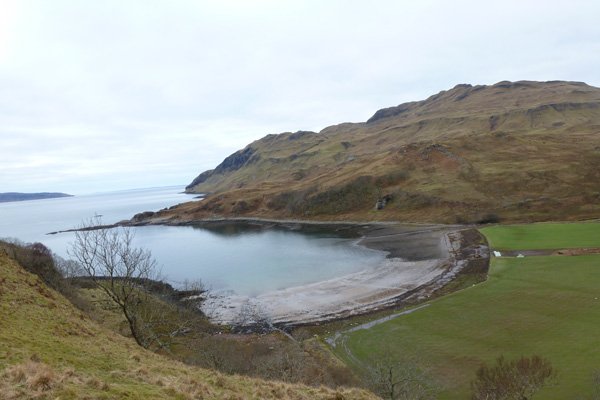
Wild About Lochaber

Wild About Lochaber

where great adventures begin...

Search form

Menu

  • Home
  • Explore
    • Wild Lochaber
    • Ardnamurchan, Moidart & Morvern
    • Fort William and Glen Nevis
    • Glencoe and Loch Leven
    • The Road To The Isles
    • #WildLochaber Photo Gallery
  • Accommodation
    • Hotels and B&Bs
    • Caravan & Campsites
  • Walking
    • Map of All Walks
    • Ardnamurchan and Moidart
    • Arisaig Mallaig and Glenfinnan
    • Fort William and Glen Nevis
    • Glencoe, Loch Leven & Argyll
  • Wildlife
    • Map of Wildlife Sites
    • Wildlife Experiences
    • Wildlife Habitats
  • Things To Do
    • Activity Providers
    • Beaches
    • Castles
    • Destinations
    • Gardens
    • Geology
    • Geopark Rock Route
    • Historic Attractions
    • Museums and Interpretation
    • Railways
    • Wildlife Experiences
    • Wildlife Hotspots
  • Travel
    • Electric Vehicle Charging Points
    • Ferries
    • Petrol Stations
    • The Caledonian Sleeper
  • What's On
    • Calendar
    • Arts, Culture and Community Events
    • Family Friendly Events
    • Walking Events
    • Wildlife & Geology Events
    • Events on Discover Glencoe
    • Road to The Isles & Ardnamurchan
  • Blogs
    • Ardnamurchan Area Blogs
    • Glencoe Area Blogs
    • Lochaber Blogs
    • West Coast Island Blogs
    • Wild About Lochaber Blog

Camas nan Geall

  • Camas nan Geall
  • folded rock formations
  • Maclean's Nose to the west
  • Looking eastwards along the coast
  • Oyster catchers on the beach
  • We walked as far as the fence line
  • Cepea shells by a thrush's anvil
  • View from the old fort
  • The Lochaber geopark interpretation board at teh Camas nan Gaell car park
  • Looking over towards Ben Hiant

Details

An interesting walk along the rocky shore line from the inlet at Camus nan Geall on the Ardnamurchan peninsula.  The fertile ground on Camus nan Geall  has a long history of settlement as evidenced by an ancient chambered cairn and standing stone.   The site has also served as a burial ground for Campbells of Ardslignish as evidenced by some carved gravestones.

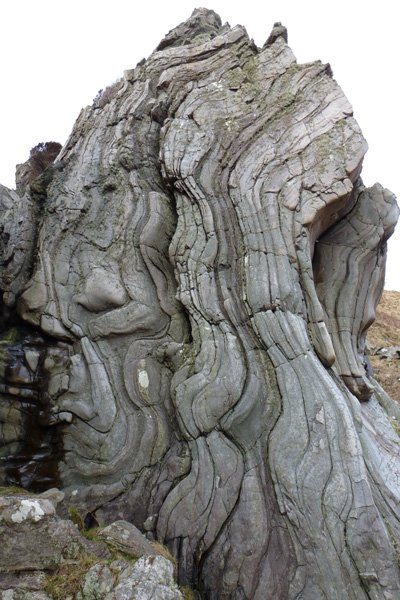
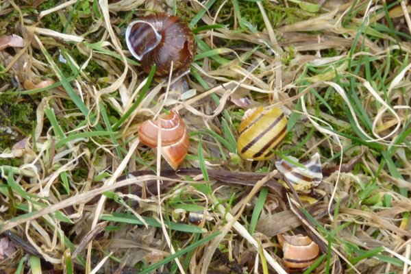
The walk is mainly across rough pasture, wet meadow, heath and shingle bays.  Look out for flag iris, water parsley and devils bit scabious on route and interesting coastal flora.    The rocks and boulders support colourful assemblages of crustiose lichens forming complex mosaics and patchworks. There are also some interesting geological formations including some heavy folded and contorted Moinian metamorphic rocks on route.  The bedrock is granofelsic psamite (Morar Group); a metamorphic rock formed 545 to 1000 million years ago, with some Palaeogene micro-gabbro and basaltic dyke intrusions. 

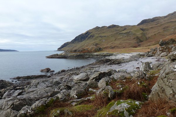
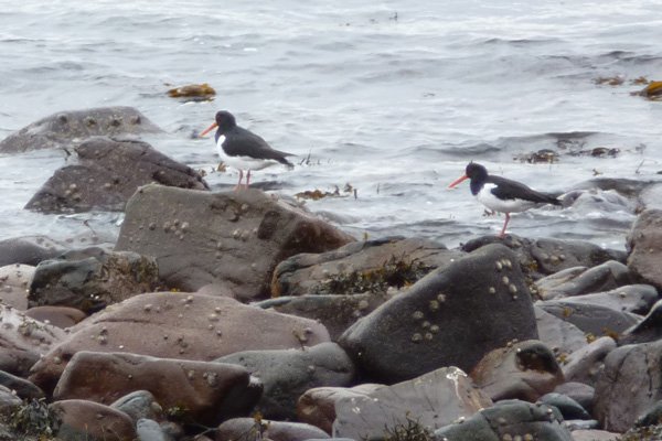
Look out for otters, cormorants and shags, white-tailed eagle and waders along the coast; pipits, ravens and golden eagle across heath and hills. The shoreline, with its numerous rocky promontories, is also particularly interesting at low tide with a good zonation of brown seaweeds and kelp forests.  A good place for a seashore safari.

The path is reasonable distinct, but there are some sections where you need to scramble over rocks and walk across shingle beaches. The route can also be very muddy and indistinct in places and there are a couple of small stream crossings.

Route details

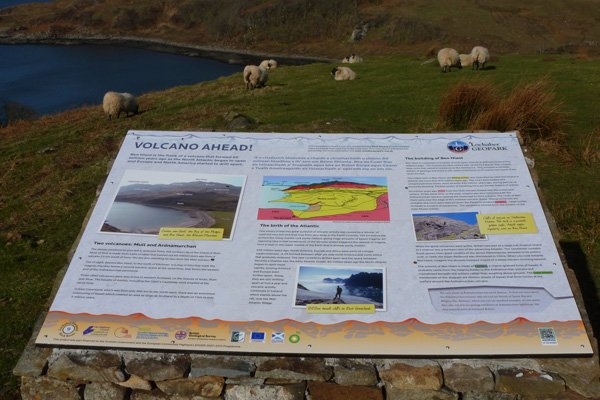
1. Park at the view point on the B8007, where there is an interesting interpretation board showing the key geological and landmark features associated with the Ben Hiant Intrusion.  Head down the track through a fertile field towards the bay passing through a couple of kissing gates and onto the shore; taking care at the last gate as it may be very muddy. The track is lined with some fine specimen sycamore trees and there is evidence of an early agricultural settlement, in the form of the remains of an ancient chambered cairn.  Only part of the chamber and forecourt have survived, but there is also a standing stone about 90 metres south by the ruins of an old chapel.   

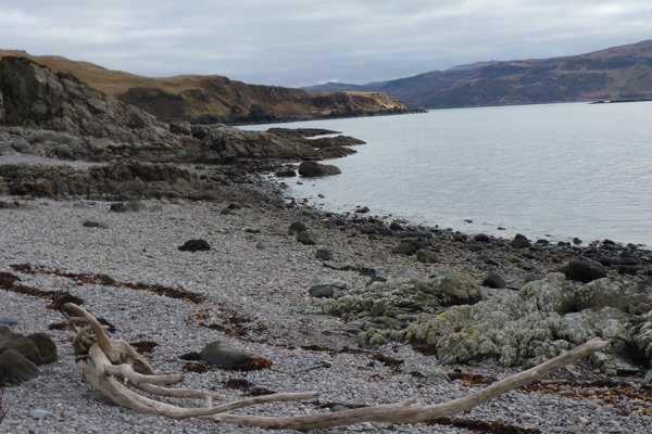
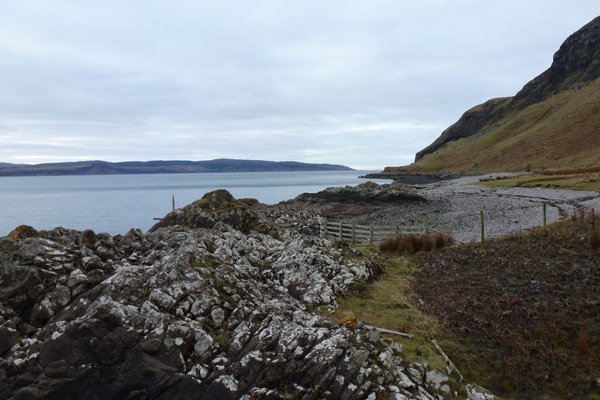
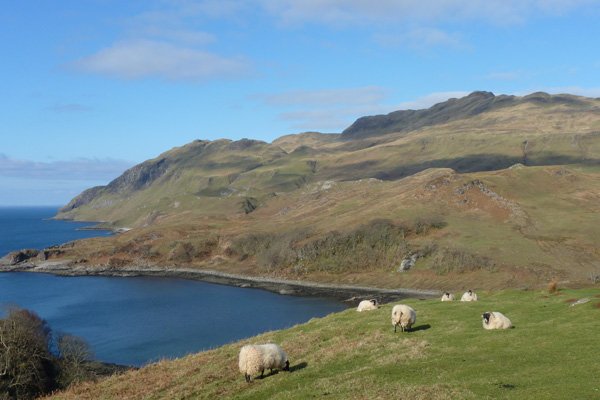
2. Once on the shingle beach, turn right and follow the foreshore, crossing a small stream and then over shingle and small boulders to the small headland.  The shingle and small boulders make for slow progress, but once over the headland the path is relatively easy to make out and follow.  The route winds along the coast with some stretches inland across rough pasture, wet meadow, as well as across several impressive small shingle bays beneath the inspiring backdrop of the Ardnamurchan hills. There is a particular interesting geological formations along a narrow ravine which you pass through after the first headland.

The path can be very boggy in places.  There are some scrambles over large boulders and the shingle beach crossings.

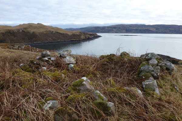
3. After some 2 km the coast meets a fence line which can be crossed if you wish to extend the walk to the jutting headland called Maclean's Nose.  You can also extend the walk by ascending to the deserted village of Bourblaige

4. Return by the same route, take time to visit the remains of an old fort on the small headland immediately west of Camus nan Geall on your return.

This walk offers lovely views of the Ardnamurchn coastline, but is not one for the quality of the walking experience.


Location

starting grid ref: 

NM563616

Links to useful information

  • Camas nan Geall Chambered Cairn
  • Camas nan Geall
  • Camas nan Geall Beach
  • Bourblaige Cleared Settlement Walk

grade: 

  • moderate

terrain: 

path, track and shingle beach

length: 

5.4km (3.4 miles)

Type: 

  • there and back

Map: 

OS Explorer Map 390 - Ardnamurchan

OS Map

>>view map in full window

Google Map

Safety

Route details and information are provided in good faith.  All walking is potentially dangerous and it is your responsibility to ensure that you are properly dressed and equipped, have a map and compass, have checked and planned your route in advance and are able to navigate effectively.  Maps displayed on these walking pages are intended as an overview of the walk and are NOT suitable for navigation.  Please follow the Scottish Outdoor Access Code and respect landowners and residents' privacy.  Always check the weather forecast and let others know if you are walking in the hills.

Walking

  • Walking Overview
  • Map of All Walks
  • Ardnamurchan and Moidart
  • Arisaig, Mallaig and Glenfinnan
  • Fort William and Glen Nevis
  • Glencoe, Loch Leven & Argyll
Booking.com

Holiday Cottages in Fort William and Lochaber

Muthu Fort William Hotel

The Muthu Fort William Hotel was formerly known as The West End Hotel and is situated at the west end of the High Street and affords some stunning mountain and loch views.  The central location is ideal for exploring the attractions on The High Street in Fort William and the hotel is just a short distance from Loch Linnhe where otters can sometimes be seen on the jetty by the nearby Crannog.

Ardnamurchan Walking Pages

  • Alphabet Trail
  • Aoineadh Mor
  • Ardmolich Woodland Walk
  • Ardnastaing and Scotstown
  • Ardtornish Castle
  • Ariundle Oakwoods
  • Bay MacNeil Beach
  • Bay of Flies
  • Ben Hiant
  • Ben Resipole
  • Blain Burn Circular
  • Bourblaige Cleared Settlement
  • Camas nan Geall
  • Castle Tioram Circular
  • Castle Tioram Viewpoint
  • Claish Plantation
  • Corrantee Lead Mines from Ardnastaing
  • Corrantee Lead Mines from Polloch
  • Dalilea Walks
  • Dorlin Low Road
  • Fairy Walk
  • Fascadale and Port Eigin-aig
  • Galmadale Dam
  • Garbh Eilean Wildlife Walk
  • Ghardail Loop
  • Glen Moidart
  • Glenborrodale Nature Trail
  • Glendrian and Port Eigin-aig
  • Greadal Fhinn Chambered Cairn
  • Kentra Bay and The Singing Sands
  • Kentra Moss Circular
  • Kilmory Beach
  • Kinlochaline Low Road
  • Kinlochmoidart Old Road
  • Loch Teacuis Northside
  • Mingary Castle
  • Ockle to The Singing Sands
  • Polloch and Loch Shiel
  • Portuairk and Bay MacNeil
  • Portuairk to Sanna
  • Prince's Walk
  • Rahoy Hills - Black Water
  • Rahoy Hills - Loch Arienas
  • Salen Oakwoods
  • Shielfoot Torr
  • Silver Walk
  • Smirisary Walk
  • Sonachan Wood and Heathland
  • St Columba's Chapel, Drimnin
  • Strontian Community Woodland
  • Tennyson's Waterfall

Glencoe

Discover Glencoe

Glencoe and Loch Leven

>>

Walking

Walking

Take a Walk on The Wild Side...

with over 100 wildlife focused walks across Lochaber, you'll be spoilt for choice

>>

Fort William

Fort William

Fort William, The Outdoor Capital

>>

Wildlife

wildlife

Wildlife

Home to Scotland's Big Five, red deer, golden eagle, otter, red squirrel, seals and so much more. A Wildlife Adventure Awaits.

>>

Ardnamurchan

West Highland Peninsulas

Ardnamurchan and The West Highland Peninsulas

>>

Activities

Activities

Activities

kayaking, wildlife watching, cruising, cycling, golfing, climbing, skiing, slow adventures and many more things to do

>>

Road to The Isles

The Road to The Isles

The Road to The Isles

>>

Day Trips

Day trips

Day Trps

Take off for the day to see the puffins on The Treshnish Isles, A Day trip to Mull, Skye, The Small Isles, The Most westerly point on the mainland and many more local ideas for a day out

>>

  • Advertising
  • Contact
  • Disclaimer
  • Privacy Policy

Photos and Content Copyright ©2011-2025 Wild About Lochaber - All Rights Reserved

  • Wild About Lochaber on Instagram
  • Wild About Lochaber on FaceBook
  • Wild About Lochaber on Twitter