


Castle Tioram Circular


A very pleasant and interesting walk through woodland, heathland, moorland and along coastal tracks with stunning views over Loch Moidart with its many pine clad islands and Castle Tioram.
The route follows small water courses lined with mainly alder, birch, ash, willow and ash; the trunks and branches of which support an abundance and diversity of crustiose, foliose and shrubby lichens (with representatives of Lobarion, Parmelion and Usneion communities), as well as bryophytes in the wetter microclimates. Look out for the intricate patchwork of crustiose lichens (Graphidion) on scattered ash trees. The route also passes through sections of heath consisting of Calluna-Erica assemblages and purple moor grass and hard fern, and with bog myrtle and sedges in the wetter areas. There is considerable encroachment of bracken in some areas.
The path starts at the site of old settlement of Scardoish (now disappeared) and passes by the ruined village of Briaig, affording the opportunity to explore this long abandoned settlement (a small cluster of houses and animal shelters). The former inhabitants were evicted in 1846, with the creation of a large sheep farm. Many of the lower houses have corn kilns, and the largest of the buildings is thought to be a corn store.
Another point of interest is a large boulder with an indent in the top by the pipeline near the dammed loch/resevoir; this is thought to the place where Alan (14th chief of the Clanranald) paused on his way to support the 1715 Jacobite Uprising. The stone is known as Clanranald's seat (see Moidart History Walk 5 for further details). Other sources suggest that this was the place or nearby where Alan watch the burning of Castle Tioram at his instigation to prevent it falling into the Government hands following his departure.
Look out for buzzard, golden eagles and raven in the hills, and black throated divers, red throated divers, whooper swans, golden ringed dragonflies (Cordulegaster boltonii), common blue damselfly (Enallagma cyathigerum) and Highland darter (Sympetrum nigrescens) in the lochs, according to season. Look for the tracks and signs of pine marten and wild cat.
Near the coast, there are a variety of waterfowl and waders, including curlew, oystercatcher and heron, as well as the chance of spotting sea eagle and otter.
The bedrock in the surrounding area is mainly metamorphic consisting variously of granofelsic psammite, schistose pelite and gneiss, or schistose semipellite and granofel (Morar Group), with scattered igneous intrusions of basalt and microgabbro.
The path is combination of bare earth, grass, gravel, stone and tarmac road.
See Moidart History Walk 5 (A Walk to the Deserted Settlement of Briag) for an historical perspective on the deserted settlement of Briag. See Moidart History Walk 4 (a Visit to Elieam Tioram and Castle Tioram) for an historical perspective on Castle Tioram.
Route Details
1. Park at the layby overlooking Loch Moidart opposite a blue painted wooden cottage (Scarduish). Cross the stile and follow the fence line towards the woods, passing by the side of Scarduish cottage.
2. Ascend the stony and boggy path following a tree-fringed burn and metal pipeline on the right (installed in 1947 as part of a hydroelectric scheme supporting a fish processing plant at Dorlin). The trees are alder, birch, ash, willow and oak; the trunks and branches of which support an abundance and diversity of crustiose, foliose and shrubby lichens (with representatives of Lobarion, Parmelion and Usneion communities), as well as bryophytes in the wetter microclimates.
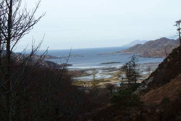
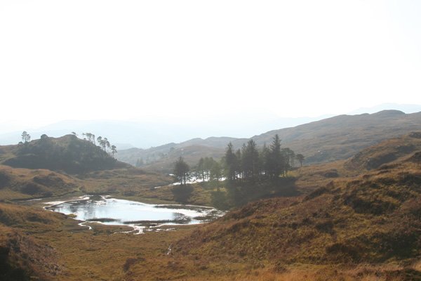
3. Continue ascending, looking back on occasion for fine views of Loch Moidart and the Small Isles (Eigg, Muck and Rum). Soon a dammed lochan comes into view, with views of Ben Resipole behind.
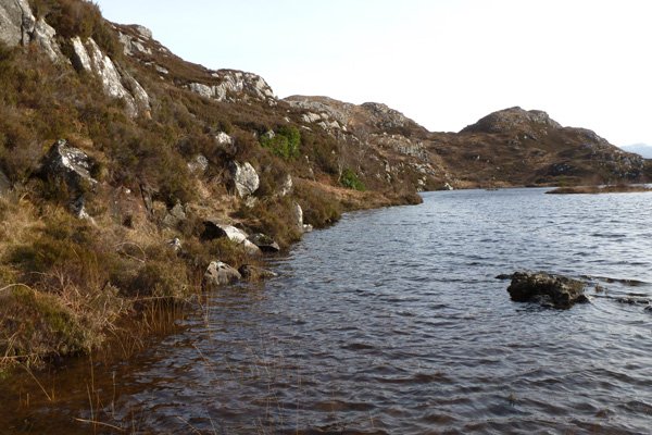
4. Skirt by the side of this lochan on a narrow, tricky path cutting through mature Calluna heath. Take care as the path can be rather slippery.
5. Descend towards another lochan ( Loch na Fola). Soon you will see a hawthorn tree and a stone cairn on the left, where two paths meet. Turn left to continue on the Castle Tioram walk.
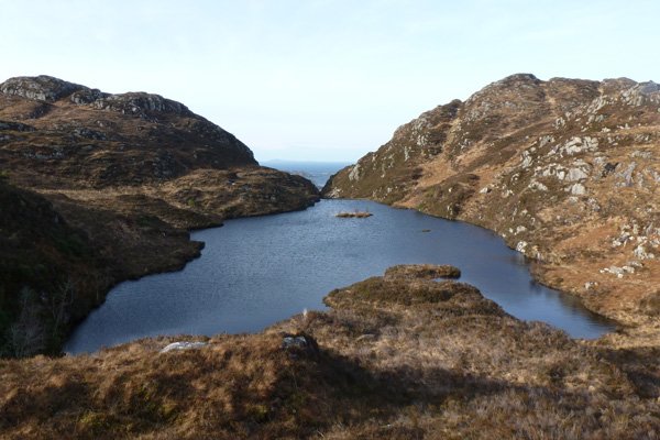
6. The path skirts round the northern edge of the lochan with good views of the surrounding hills before ascending between the two hills. The path skirts by a rocky outcrop supporting a stunted rowan tree (Sorbus aucuparia).
7. At the T junction with another path, turn left for a viewpoint or turn right to continue on the walk, skirting around the edge of the low ridge.
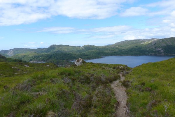
8. The path soon begins to descend, passing by a cairn, between the hills of Beinn Bhreac and Cruach nam Meann across Calluna heath and heading towards the coast. As you approach the coast, there are lovely views of Loch Moidart and the islands of Eilean Shona, Shona Beag, Eilean an Fheidh and the lovely pine studded island of Risca. The route passes within view of the deserted village of Briaig.
9. The path continues through a small birch copse and descends to Loch Moidart. Turn left where the path meets the coastal path ( part of the Silver Walk), identified by a cairn.
This is a lovely section of the walk as the path skirts along the edge of Cruach nam Meann through heath and coastal woodland. The latter consisting of Scots pine, birch, rowan, oak, ash, hazel and aspen. The ground flora is particularly lovely in Spring and early Summer. The path ascends and descends with some level sections and involves some scrabbling over rocks. Care should also be exercised over a boulder constructed bridge by the edge of shoreline. Can also be vertiginous in places.
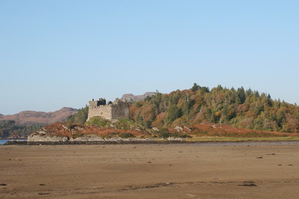
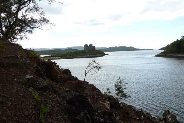
There are some lovely views of Castle Tioram, as you approach the tidal island of Eilean Tioram; Castle Tioram, now ruined, is a nationally important scheduled monument and the former stronghold of the Clanranalds.
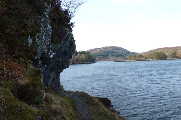
10. The path passes through a metal gateway before descending to the beach at Dorlin. The route continues passed Dorlin Cottage and along the Low Dorlin Road (private road) which skirts by the coast. The road affords fabulous view of the loch, resplendent both at low and high tide. There are some lovely views of the surrounding hills, crags and the islands.
11. On reaching a track by a burn, turn left and head uphill. Turn left at the top and return to the layby.
starting grid ref
Links to useful Information
terrain
length
Safety
Route details and information are provided in good faith. All walking is potentially dangerous and it is your responsibility to ensure that you are properly dressed and equipped, have a map and compass, have checked and planned your route in advance and are able to navigate effectively. Maps displayed on these walking pages are intended as an overview of the walk and are NOT suitable for navigation. Please follow the Scottish Outdoor Access Code and respect landowners and residents' privacy. Always check the weather forecast and let others know if you are walking in the hills.


