Wild About Lochaber

Wild About Lochaber

where great adventures begin...

Search form

Menu

  • Home
  • Explore
    • Wild Lochaber
    • Ardnamurchan, Moidart & Morvern
    • Fort William and Glen Nevis
    • Glencoe and Loch Leven
    • The Road To The Isles
    • #WildLochaber Photo Gallery
  • Accommodation
    • Self Catering
    • Caravan & Campsites
    • Hotels and B&Bs
  • Walking
    • Map of All Walks
    • Ardnamurchan and Moidart
    • Arisaig Mallaig and Glenfinnan
    • Fort William and Glen Nevis
    • Glencoe, Loch Leven & Argyll
  • Wildlife
    • Map of Wildlife Sites
    • Wildlife Experiences
    • Wildlife Habitats
  • Things To Do
    • Activity Providers
    • Beaches
    • Castles
    • Destinations
    • Gardens
    • Geology
    • Geopark Rock Route
    • Historic Attractions
    • Museums and Interpretation
    • Railways
    • Wildlife Experiences
    • Wildlife Hotspots
  • Travel
    • Electric Vehicle Charging Points
    • Ferries
    • Petrol Stations
    • The Caledonian Sleeper
  • What's On
    • Calendar
    • Arts, Culture and Community Events
    • Family Friendly Events
    • Walking Events
    • Wildlife & Geology Events
    • Events on Discover Glencoe
    • Road to The Isles & Ardnamurchan
  • Blogs
    • Ardnamurchan Area Blogs
    • Glencoe Area Blogs
    • Lochaber Blogs
    • West Coast Island Blogs
    • Wild About Lochaber Blog

Galmadale Dam

  • Galmadale Dam
  • Map and interpretation board in the car park area
  • The bridge over Glengalmindale River at the start of the walk
  • The beech tree avenue at the start of the Galmadale Dam walk
  • The track is very easy to follow up to the Galmadale Dam
  • Looking over the Glengalmadale River to Creach Bheinn
  • Galmadale Dam in Glen Galmadale
  • Galmadale Dam built between 1908 and 1910
  • The Glengalmadale River
  • Once passed the Galmadale Dam the path become indistinct and very boggy

Details

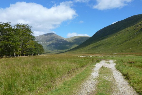
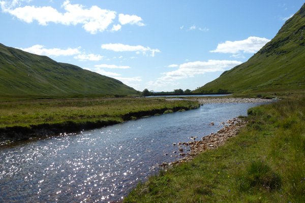
A walk along a track following the banks of meandering Glengalmadale River to Glen Galmadale Dam with its fish ladder.  There are lovely views of the surrounding high ridges, with the peaks of Beinn na Cille, Fuar Bheinn, Creach Bheinn, Maol Odbar,  Meall nan Each dominating the landscape; part of the Galmadale Horseshoe.   A complete circuit of the ridges forms part of the  strenuous 16km Creach Bheinn & Fuar Bheinn: Galmadale round walk.

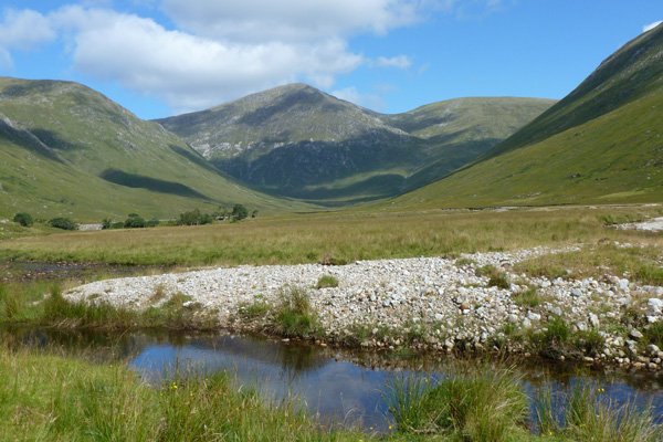
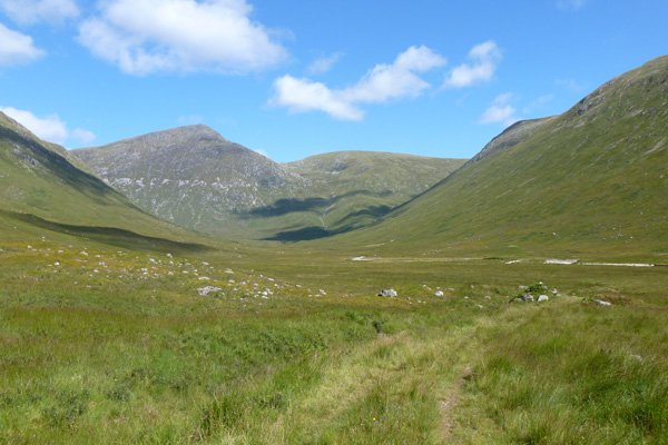
This is a lovely gently walk in a flat U-shaped valley across wet heath and grassland, with wooded sections (consisting mainly of beech, rowan, spruce and alder; both natural and planted).  The herbaceous flora is variously hued throughout the season with purple moor grass (Molina caerulea), heather (Calluna vulgaris), bell heathers (Erica tetralix and E. cinerea), bog myrtle (Myrica gale) and bog asphodel (Narthecium ossifragum) and devil’s-bit scabious (Succisa pratensis), with meadowsweet (Filipendula ulmaria) and marsh ragwort (Senecio aquaticus) in wetter areas. Insectivorous plants, such as butterworts and sundews (Pinguicula and Drosera spp) and variety of Sphagnum species characterise the boggy sections.

The track is clearly defined although some sections can be very muddy; there is also ford crossing, which may be impassable after heavy rain.

The track stops just after the Glen Galmadale Dam at a footbridge, but you can continue to a waterfall seen in the distance,  passing through several fords on route marking the outflow of numerous mountain  burns into the River.  However, this section (marked as a footpath on the OS map) is not included in this walk as the path is very indistinct and traverses wet heath and bog.  This section should only be done by experienced walkers with waterproof footwear, walking pole, map and compass.

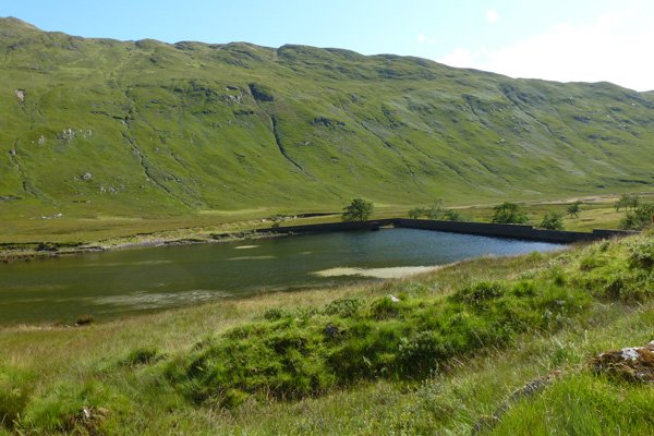
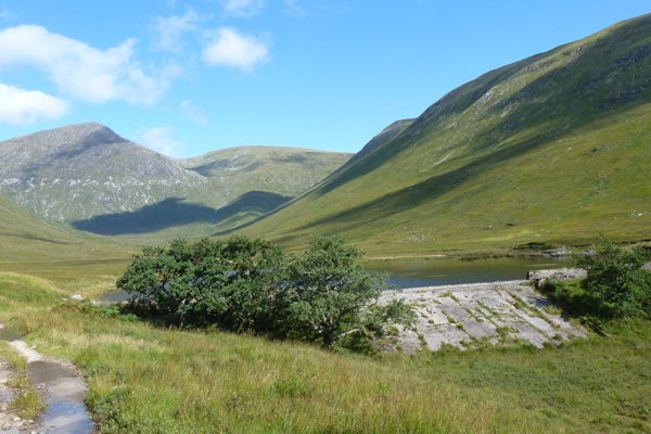
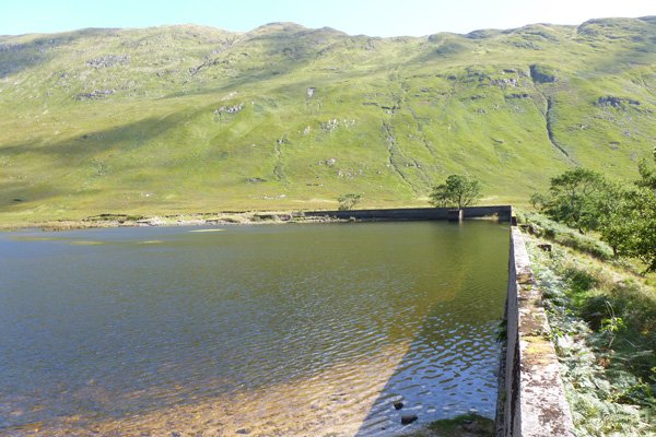
Glen Galmadale Dam and its fish ladder were designed by Malloch of Perth and built between 1908 and 1910 to provide a freshwater fishing loch for the Kingairloch Estate.  The fishing ladder was designed to allow natural colonisation of the ‘loch’ by salmon and trout.  Unfortunately, the design of the dam was ill conceived, being subject to flooding, and the ladder failed to function as intended.  The aspiration of an income source from estate fishing had to be abandoned after considerable expense. 

Look out for raptors, corvids and red deer in the hills, and pipits and larks on the heath land.  Take time for a spot of dragonfly stalking on route. 

In the wider area, the remains of nine structures surviving as ‘dry stone footings with varying levels of preservation’ have been recorded by Royal Commission on Ancient and Historical Monuments Scotland (RCAHMS).  These have been identified as possible shielings huts (small stone seasonal dwelling in upland areas for inhabitants tending livestock).

It is advisable to contact Kingairloch Estate before walking in the area during the stalking season.  

Route Details

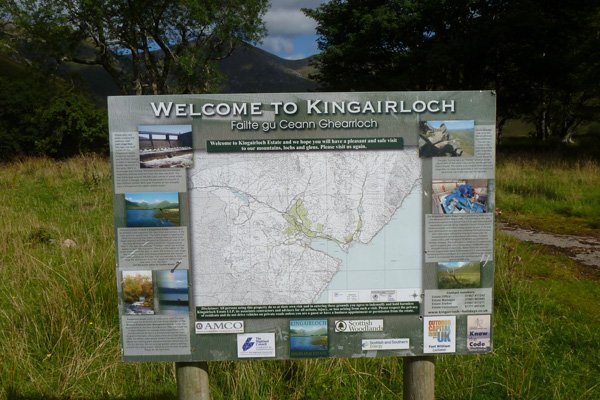
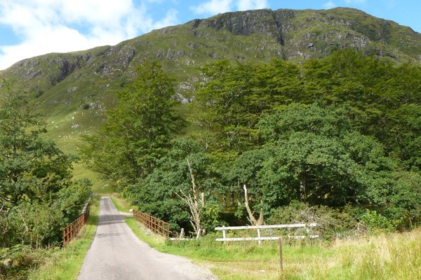
1. Park at the designated car park just east of Glengalmadale River.  There is an interpretation board by Kingairloch Estate displaying the route of the walk.  The start of the walk is on a track just west of Glengalmadale River, i.e over the road bridge.  Take the track through the metal gate (which may be open) and follow the track as it skirts along the tree-lined banks of the River. 

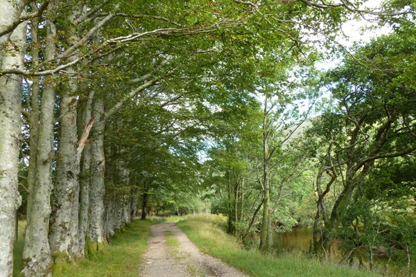
You are immediately welcomed by a fine row of beech on the left, before the track crosses heath and grassland, with patches of woodland and plantation on the left.  

2. Cross the ford and then pass through another metal gate by a shooting range (with metal deer target and stands). 

The track passes by the western edge of the Glen Galmadale Dam whose southern edge is reinforced by concrete, and the associated fish ladder.  Take time to admire this ill-fated structure, constructed as a  freshwater fishing loch in the 1900s at considerable expense. 

3. The track finishes at a rickety bridge, where you have opportunity to admire the waterfall in the distance and the ridge fabulous views in all directions. 

4. Return by the same route. 

You can continue to the waterfall, although the footpath is indistinct and traverses a bog.  This route is not advisable after wet weather as the river is subject to flooding and can be dangerous.

Location

starting grid ref: 

NM867531

Links to useful information

  • Galmadale Dam and Fish Ladder
  • Glen Galmadale Shieling Hut
  • WalkHighlands - Galmadale Ridge Walk

grade: 

  • easy

terrain: 

track

length: 

3.2 km (2 miles)

Type: 

  • there and back

Map: 

OS Explorer 383 - Morvern

OS Map

>>view map in full window

Google Map

Safety

Route details and information are provided in good faith.  All walking is potentially dangerous and it is your responsibility to ensure that you are properly dressed and equipped, have a map and compass, have checked and planned your route in advance and are able to navigate effectively.  Maps displayed on these walking pages are intended as an overview of the walk and are NOT suitable for navigation.  Please follow the Scottish Outdoor Access Code and respect landowners and residents' privacy.  Always check the weather forecast and let others know if you are walking in the hills.

Walking

  • Walking Overview
  • Map of All Walks
  • Ardnamurchan and Moidart
  • Arisaig, Mallaig and Glenfinnan
  • Fort William and Glen Nevis
  • Glencoe, Loch Leven & Argyll
Booking.com

Holiday Cottages in Fort William and Lochaber

The Kilchoan Hotel
The Kilchoan Hotel

The Kilchoan Hotel is situated in the small village of Kilchoan on the Ardnamurchan Peninsula.

Ardnamurchan Walking Pages

  • Alphabet Trail
  • Aoineadh Mor
  • Ardmolich Woodland Walk
  • Ardnastaing and Scotstown
  • Ardtornish Castle
  • Ariundle Oakwoods
  • Bay MacNeil Beach
  • Bay of Flies
  • Ben Hiant
  • Ben Resipole
  • Blain Burn Circular
  • Bourblaige Cleared Settlement
  • Camas nan Geall
  • Castle Tioram Circular
  • Castle Tioram Viewpoint
  • Claish Plantation
  • Corrantee Lead Mines from Ardnastaing
  • Corrantee Lead Mines from Polloch
  • Dalilea Walks
  • Dorlin Low Road
  • Fairy Walk
  • Fascadale and Port Eigin-aig
  • Galmadale Dam
  • Garbh Eilean Wildlife Walk
  • Ghardail Loop
  • Glen Moidart
  • Glenborrodale Nature Trail
  • Glendrian and Port Eigin-aig
  • Greadal Fhinn Chambered Cairn
  • Kentra Bay and The Singing Sands
  • Kentra Moss Circular
  • Kilmory Beach
  • Kinlochaline Low Road
  • Kinlochmoidart Old Road
  • Loch Teacuis Northside
  • Mingary Castle
  • Ockle to The Singing Sands
  • Polloch and Loch Shiel
  • Portuairk and Bay MacNeil
  • Portuairk to Sanna
  • Prince's Walk
  • Rahoy Hills - Black Water
  • Rahoy Hills - Loch Arienas
  • Salen Oakwoods
  • Shielfoot Torr
  • Silver Walk
  • Smirisary Walk
  • Sonachan Wood and Heathland
  • St Columba's Chapel, Drimnin
  • Strontian Community Woodland
  • Tennyson's Waterfall

Glencoe

Discover Glencoe

Glencoe and Loch Leven

>>

Walking

Walking

Take a Walk on The Wild Side...

with over 100 wildlife focused walks across Lochaber, you'll be spoilt for choice

>>

Fort William

Fort William

Fort William, The Outdoor Capital

>>

Wildlife

wildlife

Wildlife

Home to Scotland's Big Five, red deer, golden eagle, otter, red squirrel, seals and so much more. A Wildlife Adventure Awaits.

>>

Ardnamurchan

West Highland Peninsulas

Ardnamurchan and The West Highland Peninsulas

>>

Activities

Activities

Activities

kayaking, wildlife watching, cruising, cycling, golfing, climbing, skiing, slow adventures and many more things to do

>>

Road to The Isles

The Road to The Isles

The Road to The Isles

>>

Day Trips

Day trips

Day Trps

Take off for the day to see the puffins on The Treshnish Isles, A Day trip to Mull, Skye, The Small Isles, The Most westerly point on the mainland and many more local ideas for a day out

>>

  • Advertising
  • Contact
  • Disclaimer
  • Privacy Policy

Photos and Content Copyright ©2011-2023 Wild About Lochaber - All Rights Reserved

  • Wild About Lochaber on YouTube
  • Wild About Lochaber on Pinterest
  • Wild About Lochaber on Instagram
  • Wild About Lochaber on FaceBook
  • Wild About Lochaber on Twitter
Share/Save