Wild About Lochaber

Wild About Lochaber

where great adventures begin...

Search form

Menu

  • Home
  • Explore
    • Wild Lochaber
    • Ardnamurchan, Moidart & Morvern
    • Fort William and Glen Nevis
    • Glencoe and Loch Leven
    • The Road To The Isles
    • #WildLochaber Photo Gallery
  • Accommodation
    • Self Catering
    • Caravan & Campsites
    • Hotels and B&Bs
  • Walking
    • Map of All Walks
    • Ardnamurchan and Moidart
    • Arisaig Mallaig and Glenfinnan
    • Fort William and Glen Nevis
    • Glencoe, Loch Leven & Argyll
  • Wildlife
    • Map of Wildlife Sites
    • Wildlife Experiences
    • Wildlife Habitats
  • Things To Do
    • Activity Providers
    • Beaches
    • Castles
    • Destinations
    • Gardens
    • Geology
    • Geopark Rock Route
    • Historic Attractions
    • Museums and Interpretation
    • Railways
    • Wildlife Experiences
    • Wildlife Hotspots
  • Travel
    • Electric Vehicle Charging Points
    • Ferries
    • Petrol Stations
    • The Caledonian Sleeper
  • What's On
    • Calendar
    • Arts, Culture and Community Events
    • Family Friendly Events
    • Walking Events
    • Wildlife & Geology Events
    • Events on Discover Glencoe
    • Road to The Isles & Ardnamurchan
  • Blogs
    • Ardnamurchan Area Blogs
    • Glencoe Area Blogs
    • Lochaber Blogs
    • West Coast Island Blogs
    • Wild About Lochaber Blog

Geopark Rock Route 9 - Ben Hiant

  • Lochaber Geopark Rock Route No 9
  • Ben Hiant

Details

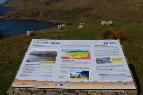
An interesting interpretation board providing an oversight of the geology of the region with reference to origins of Ben Hiant, a mountain which rises  to a height of 528m and dominates the Ardnamurchan peninsula.  This interpretation describes the geology of Ben Hiant, and the important role volcanoes have played in the region; western Scotland has five volcanic centres (Ardnamurchan peninsula, Mull, Rum, Skye and Arran).  

The board describes how Ben Hiant is the flank of a volcano, formed around 60 million years ago, and illustrates its diverse geology (quartz-dolerite, breccias, pitchstone, basalt lavas, cone sheets and Moine schist).

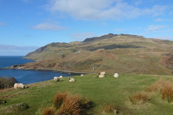
The board is located in a large layby overlooking Camas na Geall by Ardslignish off the B8007. 

An excellent, well sited, interpretation board on the geology of region.  

Location

starting grid ref: 

NM562617

Links to useful information

  • Interpretation Board No 9: Details
  • Lochaber Geopark

OS Map

Things To Do

  • Things To Do
  • Activity Providers
  • Beaches
  • Castles
  • Destinations
  • Gardens
  • Geology
  • Geopark Rock Route
  • Historic Attractions
  • Museums and Interpretation
  • Railways
  • Wildlife Experiences
  • Wildlife Hotspots

Glencoe

Discover Glencoe

Glencoe and Loch Leven

>>

Walking

Walking

Take a Walk on The Wild Side...

with over 100 wildlife focused walks across Lochaber, you'll be spoilt for choice

>>

Fort William

Fort William

Fort William, The Outdoor Capital

>>

Wildlife

wildlife

Wildlife

Home to Scotland's Big Five, red deer, golden eagle, otter, red squirrel, seals and so much more. A Wildlife Adventure Awaits.

>>

Ardnamurchan

West Highland Peninsulas

Ardnamurchan and The West Highland Peninsulas

>>

Activities

Activities

Activities

kayaking, wildlife watching, cruising, cycling, golfing, climbing, skiing, slow adventures and many more things to do

>>

Road to The Isles

The Road to The Isles

The Road to The Isles

>>

Day Trips

Day trips

Day Trps

Take off for the day to see the puffins on The Treshnish Isles, A Day trip to Mull, Skye, The Small Isles, The Most westerly point on the mainland and many more local ideas for a day out

>>

  • Advertising
  • Contact
  • Disclaimer
  • Privacy Policy

Photos and Content Copyright ©2011-2023 Wild About Lochaber - All Rights Reserved

  • Wild About Lochaber on YouTube
  • Wild About Lochaber on Pinterest
  • Wild About Lochaber on Instagram
  • Wild About Lochaber on FaceBook
  • Wild About Lochaber on Twitter
Share/Save