Wild About Lochaber

Wild About Lochaber

where great adventures begin...

Search form

Menu

  • Home
  • Explore
    • Wild Lochaber
    • Ardnamurchan, Moidart & Morvern
    • Fort William and Glen Nevis
    • Glencoe and Loch Leven
    • The Road To The Isles
    • #WildLochaber Photo Gallery
  • Accommodation
    • Self Catering
    • Caravan & Campsites
    • Hotels and B&Bs
  • Walking
    • Map of All Walks
    • Ardnamurchan and Moidart
    • Arisaig Mallaig and Glenfinnan
    • Fort William and Glen Nevis
    • Glencoe, Loch Leven & Argyll
  • Wildlife
    • Map of Wildlife Sites
    • Wildlife Experiences
    • Wildlife Habitats
  • Things To Do
    • Activity Providers
    • Beaches
    • Castles
    • Destinations
    • Gardens
    • Geology
    • Geopark Rock Route
    • Historic Attractions
    • Museums and Interpretation
    • Railways
    • Wildlife Experiences
    • Wildlife Hotspots
  • Travel
    • Electric Vehicle Charging Points
    • Ferries
    • Petrol Stations
    • The Caledonian Sleeper
  • What's On
    • Calendar
    • Arts, Culture and Community Events
    • Family Friendly Events
    • Walking Events
    • Wildlife & Geology Events
    • Events on Discover Glencoe
    • Road to The Isles & Ardnamurchan
  • Blogs
    • Ardnamurchan Area Blogs
    • Glencoe Area Blogs
    • Lochaber Blogs
    • West Coast Island Blogs
    • Wild About Lochaber Blog

Geopark Rock Route 3 - Trislaig

  • Lochaber Geopark Rock Route No 3
  • Britain's Biggest Ben
  • The Ben Nevis Range in December
  • Geopark board No 3 is in the carpark of Trislaig Village Hall

Details

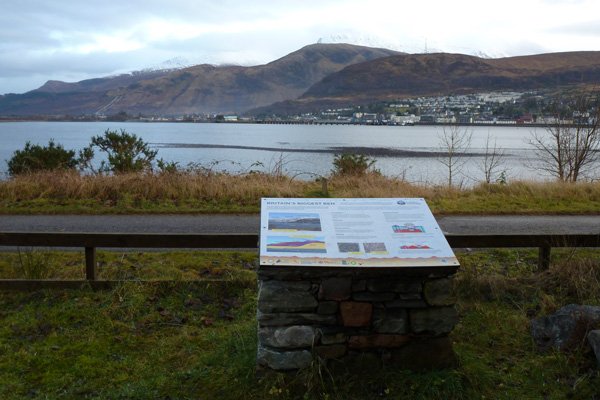
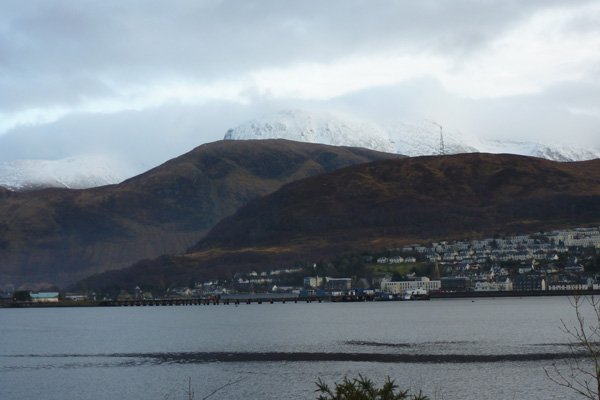
The interpretation board is located in the car park of the village hall in Trislaig.  The interpretation board is sited to provide fine views of the Ben Nevis Range (Aonach Mor, Car Mòr Dearg and Ben Nevis), as well as Cow Hill and Fort William.   The board describes the formation of the Ben Nevis Range, involving laying down of sedimentary rock, the collision of continents, metamorphism and volcanic activity over vast geological time scales. 

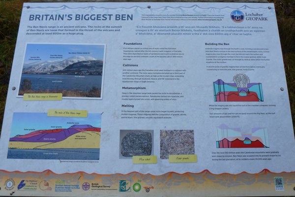
The board tells the fascinating story of the origins and geology of the Ben Nevis Range; a complex sequence of events illustrated through a series of diagrams.  Diagrams depict the formation of Ben Nevis Range, which resulted from a series of eruptions, the first around 410 million years ago to form a volcano and a large lava field (of andesite lava).  The lava erupted onto the pre-existing schists and other metamorphic rocks that formed the remains of the Caledonian mountain chain. 

Later, a large mass of magma rose and solidified in a magma chamber beneath the surface to form the coarse grain outer granite of Nevis Range.   This was followed by another upsurging of magma, followed by the collapse of the roof of the magma chamber.  The collapse of the roof led to the sinking of a cylindrical block of rocks above (andesite lava and schists) into the magma chamber; an event accompanied by further eruptions of ash, gases and lavas.  A large crater (caldera) was formed as a result.  The magma in the chamber eventually solidified to form the pink fine grained inner granite of the Nevis range.

The formation of the caldera, followed by later erosion of the lava field and surrounding schists, resulted in the distinctive geology of the Ben Nevis Range as seen today with the upper slopes consisting mainly of outer granite and inner granite, and the lower slopes dominated by quartz diorite, quartzite and schists, with dykes variously cutting through the granites.   The summit of Ben Nevis is composed of volcanic breccias and andesite lava, the remains of the eroded caldera.  Erosion, uplift and glaciation events have all left their distinctive marks. 

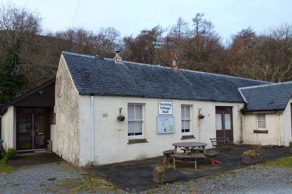
The board is located in the car park at Trisaig Village Hall just south of Camusnagaul ferry terminal.

This information board provides a great opportunity to familiarise yourself with the geology and topography of the Ben Nevis Range, with the ancient caldera volcano of Ben Nevis dominating the landscape, at a height of 1344 m.


Location

starting grid ref: 

NN093746

Links to useful information

  • Interpretation Board No 3: Details
  • Lochaber Geopark

OS Map

Things To Do

  • Things To Do
  • Activity Providers
  • Beaches
  • Castles
  • Destinations
  • Gardens
  • Geology
  • Geopark Rock Route
  • Historic Attractions
  • Museums and Interpretation
  • Railways
  • Wildlife Experiences
  • Wildlife Hotspots

Glencoe

Discover Glencoe

Glencoe and Loch Leven

>>

Walking

Walking

Take a Walk on The Wild Side...

with over 100 wildlife focused walks across Lochaber, you'll be spoilt for choice

>>

Fort William

Fort William

Fort William, The Outdoor Capital

>>

Wildlife

wildlife

Wildlife

Home to Scotland's Big Five, red deer, golden eagle, otter, red squirrel, seals and so much more. A Wildlife Adventure Awaits.

>>

Ardnamurchan

West Highland Peninsulas

Ardnamurchan and The West Highland Peninsulas

>>

Activities

Activities

Activities

kayaking, wildlife watching, cruising, cycling, golfing, climbing, skiing, slow adventures and many more things to do

>>

Road to The Isles

The Road to The Isles

The Road to The Isles

>>

Day Trips

Day trips

Day Trps

Take off for the day to see the puffins on The Treshnish Isles, A Day trip to Mull, Skye, The Small Isles, The Most westerly point on the mainland and many more local ideas for a day out

>>

  • Advertising
  • Contact
  • Disclaimer
  • Privacy Policy

Photos and Content Copyright ©2011-2023 Wild About Lochaber - All Rights Reserved

  • Wild About Lochaber on YouTube
  • Wild About Lochaber on Pinterest
  • Wild About Lochaber on Instagram
  • Wild About Lochaber on FaceBook
  • Wild About Lochaber on Twitter
Share/Save