Historic Attractions in Moidart, Ardnamurchan and The Rough Bounds including Arisaig, Mallaig, Morvern and Fort William
| 1 |
Nevis Range Mountain Discovery Centre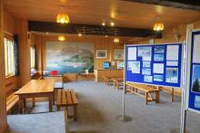 |
The Nevis Range Mountain Discovery Centre is situated by the cafe at the top of The Nevis Range Gondola and has an interesting range of exhibits and artefacts on display. |
| 2 |
The Commando Memorial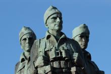 |
The Commando Memorial at Spean Bridge commemorates the British Commando Forces in the Second World War. |
| 3 |
Castle Tioram (Moidart) |
Castle Tioram, an ancient seat of the Clanranalds, is on the rocky tidal island of Eilean Tioram at the confluence of Loch Moidart and the River Shiel in Moidart. |
| 4 |
Moidart History House (Moidart) |
The Moidart History House is a small interpretation centre located next to the Glenuig Community shop on the A861 in Glenuig. Open from 1pm-4pm on Thursdays in may & June and then on Tuesdays and Thursdays in July and August. It showcases some of the excellent work of the Moidart Local History Group. |
| 5 |
Roshven House Gardens (Moidart) |
Roshven House, situated on the shores of Loch Ailort in Moidart is a historic house surrounded by over 30 acres of grounds. The gardens are open for one day a year through Scotland's Gardens open garden scheme, raising money for a range of local and national charities. |
| 6 |
Samalaman Beach (Moidart) |
Samalman Beach is a lovely sandy beach near Glenuig with fine views to the Small Isles. |
| 7 |
St Finans Isle (Moidart) |
St Finans Isle, also known as the Green Isle, has associations with St Columba, a sixth century missionary from Iona. |
| 8 |
The Seven Men of Moidart (Moidart) |
A commemoration of the seven companions who accompanied Bonnie Prince Charlie on his voyage to Moidart in 1745. |
| 9 |
Glenfinnan Church (Glenfinnan) |
Glenfinnan Church, or St Mary and St Finnan's Catholic Church, is a fine example of Pugin architecture in a stunning historic location high above the shores of Loch Shiel. |
| 10 |
The Muidhe (Glenfinnan) |
The Mudhie is one of the top 100 Geosites in the UK and Ireland |
| 11 |
Ardnamurchan Distillery (Ardnamurchan) |
The Ardnamurchan Distillery offers a range of tours throughout the year |
| 12 |
Ardnamurchan Lighthouse (Ardnamurchan) |
Ardnamurchan Lighthouse is located on the most westerly point of the Ardnamurchan peninsula and offers fine views, a tea room, shop and exhibition centre. |
| 13 |
Ardnamurchan Natural History Visitor Centre (Ardnamurchan) |
The Ardnamurchan Natural History Centre, formerly Nadurra, comprises a shop, cafe and an exhibition centre. |
| 14 |
Ardtoe Beach (Ardnamurchan) |
Ardtoe Beach is a lovely sandy beach in Ardnamurchan on The West Coast of Scotland. Great for rockpooling, swimming and birdwatching. |
| 15 |
Bay MacNeil Beach (Ardnamurchan) |
A beautiful beach at the western most end of Ardnamurchan peninsula with fabulous views of The Small Isles and Ardnamurchan Point. |
| 16 |
Bourblaige (Ardnamurchan) |
The settlement of Bourblaige is one of the best preserved cleared settlements on the Ardnamurchan peninsula. The settlement is located on the south-east flank of Ben Hiant, between Camus nan geall and Maclean's Nose. |
| 17 |
Camas nan Geall (Ardnamurchan) |
Camas nan Geall is a lovely sandy bay on the southern shores of the Ardnamurchan peninsula |
| 18 |
Cul na Croise Beach (Ardnamurchan) |
Cul na Croise Beach |
| 19 |
Geopark Rock Route 1 - Sanna Bay (Ardnamurchan) |
Land of The Rings This Lochaber Geopark board describes the Great Eucrite ring complex centred around Achnaha on the Ardnamurch peninsula. |
| 20 |
Geopark Rock Route 16 - Corran (Ardgour) (Ardnamurchan) |
The Greatest Glen Lochaber Geopark interpretation board describing the origin of the Great Glen. |
| 21 |
Geopark Rock Route 8 - Kilchoan (Ardnamurchan) |
Inside Ardnamurchan This board focuses on the Ardnamurchan volcano and the surrounding geology. |
| 22 |
Geopark Rock Route 9 - Ben Hiant (Ardnamurchan) |
Volcano Ahead An interesting interpretation board providing an oversight of the geology of the region with reference to origins of Ben Hiant. |
| 23 |
Glenborrodale Castle Gardens (Ardnamurchan) |
A very impressive and architecturally ornate castle surrounded by some lovely gardens, supporting a fine collection of rhododendrons. The gardens are currently closed to the public. |
| 24 |
Glenborrodale Nursery (Ardnamurchan) |
Be sure to stop off at Glenborrodale Nursery when you take the scenic road to Ardnamurchan Point. |
| 25 |
Greadal Fhinn Chambered Cairn (Ardnamurchan) |
Greadal Fhinn is a Neolithic chambered cairn located on the top of a knoll, 300 metres north west of Ormsaigmore on the Ardnamurchan peninsula |
| 26 |
Kilmory Beach (Ardnamurchan) |
Kilmory beach is a lovely white sandy beach punctuated with volcanic outcrops. |
| 27 |
Mingary Castle (Ardnamurchan) |
Mingary Castle, former stronghold of the MacIans of Ardnamurchan, is a medieval castle strategically located on a rocky promontory near Kilchoan, on the Ardnamuchan peninsula. |
| 28 |
Portuairk Beach (Ardnamurchan) |
Portuairk Beach |
| 29 |
Sanna Bay Beach (Ardnamurchan) |
Sanna Bay really does have it all and it is not surprising that this beach is popular with botanists, wildlife watchers, walkers, geologists, artists and photographers alike |
| 30 |
Smirisary Beach (Ardnamurchan) |
The remote beaches at Smirisary are a great place for relaxing and losing yourself. |
| 31 |
St Comghan's Church (Ardnamurchan) |
St Comghan's Church is the Old Parish Church at Kilchoan and burial ground which overlooks the village of Kilchoan and Kilchoan Bay. |
| 32 |
Swordle Bay (Ardnamurchan) |
The white sandy beach at Swordle is a great place to immerse yourself in the wilderness of Ardnamurchan peninsula. |
| 33 |
The Singing Sands (Ardnamurchan) |
The Singing Sands |
| 34 |
Viking Boat Burial Site at Swordle Bay (Ardnamurchan) |
A Viking boat burial was discovered in 2011 during excavation in the Swordle Bay; an rare and exciting find for The Ardnamurchan Transitions Project. |
| 35 |
Geopark Rock Route 13 - Mallaig (Morar and Arisaig) |
A Necklace of Volcanoes The interpretation board focuses on the four ancient volcanoes that have been responsible for shaping the Inner Hebrides. |
| 36 |
Geopark Rock Route 14 - Morar (Morar and Arisaig) |
Ancient Volcanoes This Lochaber Geopark board describes how volcanic activity has shaped the Black Cuillins and Red Hills of Skye, Askival on Rum and the plateau on Eigg |
| 37 |
Larachmhor Gardens (Morar and Arisaig) |
Larachmor Gardens are a celebration of shapes, textures and scents, and are a real treat for the botanist, gardener and artist alike. |
| 38 |
Maelrubha's Chapel (Morar and Arisaig) |
An early 16th Century runined church dedicated to St Maelrubha. The famous Gaelic poet, Alasdair mac Mhaighstir Alasdair is buried in the adjacent graveyard. |
| 39 |
Prince Charlie's Cave Arisaig (Morar and Arisaig) |
One of the caves reputed to have be used by Bonnie Prince Charlie during his escape from the Redcoats following the Jacobite defeat at Culloden. Part of a short walk to Borrodale Beach from Druimindarroch. |
| 40 |
The Prince's Cairn (Morar and Arisaig) |
The Prince's Cairn marks the historic place from which Bonnie Prince Charles embarked for France in 1746 from Loch nan Uamh. |
| 41 |
Mallaig Heritage Centre (Mallaig) |
The Mallaig Heritage Centre provides a unique insight into the landscape, history and culture of the Rough Bounds through exhibits, models and film. |
| 42 |
Land Sea and Islands Centre (Arisaig) |
The Visitor Centre in Arisaig houses an interesting collection of books, photographs, artefacts and exhibits illustrating the social, cultural and natural history of the area. |
| 43 |
Ardtornish Castle (Morvern) |
Ardtornish Castle sited on a headland jutting into the Sound of Mull approximately 2km SE of Lochaline, Morvern. The castle served as a residence and strong hold for the Lords of the Isles (chiefs of the Clan Donald) in 14th and 15th centuries. |
| 44 |
Ardtornish Gardens (Morvern) |
Ardtornish Garden is a lovely garden in a stunning setting with magnificent views over Loch Aline and The Sound of Mull. |
| 45 |
Caisteal nan Con (Morvern) |
Caisteal Nan Con, The Castle of the Hounds, is 17 century three-storeyed hall house that stands in a commanding position on a rocky promontory overlooking the Sound of Mull. |
| 46 |
Clach na Criche (Morvern) |
The Wishing Stone in Morvern is formed from a dyke that orginally intruded into surrounding rocks but now stands as a boulder like outcrop. It has served as boundary marker, a wishing stone and as a stop off point for funeral processions. |
| 47 |
Geopark Rock Route 10 - Lochaline Sand Mine (Morvern) |
Black Lava, Pure White Sand A fascinating insight into the geology and topography around Loch Aline. |
| 48 |
Geopark Rock Route 6 - Lochaline (Morvern) |
Volcanoes and Tropical Seas An excellent interpretation board exploring the effect of volcanoes and shifting continental plates on the geology and topography of Morvern. |
| 49 |
The Carved Stones of Kiel (Morvern) |
The Carved Stones of Kiel are a collection of nineteen medieval carved gravestone slabs bearing intricate Celtic art and text. The stones are arranged in the Old Session House at Kiel Church |
| 50 |
Ben Nevis Distillery (Fort William) |
Visitor Centre, tours and whisky shop at the one of the oldest licensed distilleries in Scotland. |
| 51 |
Geopark Rock Route 11 - Glen Loy (Fort William) |
Drifting Volcanoes and Drifting Continents The interpretation board overlooks the north face of Ben Nevis and describes in detail the effects of glaciers, volcanoes and continental drift on the Nevis Range. |
| 52 |
Glen Nevis Visitor Centre (Fort William) |
Glen Nevis Visitor Centre is located on the Glen Nevis Road, approximately 2km from Fort William It is run by The Highland Council and supports a Visitor Exhibition, Shop, Toilets and car parking. |
| 53 |
Great Glen Scenic Chair Ride (Fort William) |
A lovely scenic trip across the slopes of Anoach Mor in The Nevis Range to a hidden valley affording some spectacular views on route. A great trip from Fort William. |
| 54 |
Kilmallie Stone Circle (Fort William) |
A modern stone circle of rocks from the Highlands and Islands dating from between 3125 and 55 million years. A good introduction to the geodiversity of the area. |
| 55 |
Lochaber Geopark Visitor Centre (Fort William) |
Lochaber Geopark Visitor Centre in the centre of Fort William. |
| 56 |
Old Inverlochy Castle (Fort William) |
Old Inverlochy Castle, on the banks of the River Loch, is an impressive ruin that bears testament to the former power of ancient families, kingly ambition and clan rivalries. |
| 57 |
The Fort, Fort William (Fort William) |
The old fort (An Gearasdan) in Fort William is well placed as a strategic strong hold. The fort gained notoriety for its role in the infamous Glen Coe Massacre of 1692 and was besieged by the Jacobites during the uprising of1745. |
| 58 |
Treasures of the Earth (Fort William) |
The Treasures of the Earth contains one of the largest private collections of crystals and gemstones in Europe, as well as a fine collection of fossils. |
| 59 |
West Highland Museum (Fort William) |
The Museum's collections tell the story of Lochaber's rich and colourful history through diplays, objects and artefacts. |
| 60 |
Ballachulish Slate Quarry (Ballachulish)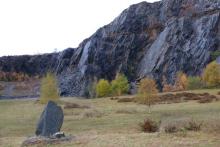 |
Ballachulish Slate Quarry was established in 1692 and thrived during the 18th Century producing many of the slate roof tiles for surrounding areas and those destined for Edinburgh and Glasgow. |
| 61 |
Geopark Rock Route 12 - Ballachulish Quarry (Ballachulish) |
Mud, Slate and Mighty Mountains The board describes the origin and properties of slate and its uses in construction. |
| 62 |
Ard Daraich Gardens (Ardgour) |
Seven acre hill garden in Ardgour on the shores of Loch Linnhe with fine collections of rhododendron, camelia, acer and sorbus in a spectacular setting. |
| 63 |
Geopark Rock Route 17 - Sallachan Bay (Ardgour) |
Two Fjords, Two Volcanoes and One Great Fault The interpretation board is sited to provide good views of the volcanic caldera of Ben Nevis and Glen Coe. |
| 64 |
Geopark Rock Route 3 - Trislaig (Ardgour) |
Britain's Biggest Ben The interpretation board is located in the car park of the village hall in Trislaig and focuses on the geology of the Ben Nevis Range. |
| 65 |
Geopark Rock Route 7 - Camusnagaul (Ardgour) |
Fjords, Faults and Fire A fascinating board describing the impact of the Great Glen Fault on the geology and topography of Lochaber. |
| 66 |
Tobermory (Isle of Mull) |
Tobermory is a popular day trip offering shopping, walks, wildlife trips, history and culture, as well as the Balmory Experience. |
| 67 |
Glenfinnan Station and Viaduct (Lochaber) |
The historic Glenfinnan Station and Viaduct on The Road to The Isles, near Glenfinnan are an impressive tribute to Victorian engineering. The station museum has an interpretation centre describing the history and construction of this historic railway. |
| 68 |
Mallaig to Fort William by Diesel Train (Lochaber) |
The Scotrail diesel service between Mallaig and Fort William provides a year round way of experiencing the splendours of The West Highland Railway with magnificent scenery and landmarks such as The Glenfinnan Viaduct and Monument. |
| 69 |
The Glenfinnan Monument (Lochaber) |
The Glenfinnan Monument is a National Trust for Scotland Property |
| 70 |
Kinloch Castle (Isle of Rum) |
Kinloch Castle is a turreted, two storey castle, with an arcaded veranda, built by the wealthy Lancashire industrialist George Bullough in 1897 |
| 71 |
Geopark Rock Route 20 - Isle of Eigg (The Small Isles) |
The Sgurr of Eigg |
| 72 |
National Trust for Scotland Glencoe Visitor Centre (Glencoe) |
The NTS Glencoe Visitor Centre consists of a Visitor Centre, Shop and Cafe. It is also the start point for the Glencoe Woodland Trail. |
| 73 |
Geopark Rock Route 4 - Glen Nevis (Glen Nevis) |
Ben and Glen Nevis - Fire and Ice Lochaber Geopark interpretation board on the origins of the Ben Nevis and the impact of glaciation. |
| 74 |
Geopark Rock Route 18 - Loch Leven (Spean Bridge) |
A Volcanic Cauldron This interpretation board describes the geology and topography of Glen Coe area, based around an ancient volcanic caldera. |
| 75 |
Geopark Rock Route 19 - Glen Roy (Spean Bridge) |
The 'Parallel Roads' of Glen Roy - How to spot an Ice Age Landscape These two boards are sited in a small car park to provide a good overview of the Parallel Roads in Glen Roy, a world famous geological feature. |
| 76 |
Geopark Rock Route 2 - Commando Memorial (Spean Bridge) |
Collision, Fire and Ice An excellent interpretation board on the formation of the Ben Nevis Range and the Grey Corries. |
| 77 |
Geopark Rock Route 5 - Loch Lochy (Spean Bridge) |
Grinding Continents This geological board describes the origin and importance of the Great Glen. |
| 78 |
Mulroy Monument (Spean Bridge) |
The Mulroy Monument commemorates the The Battle of Mulroy, fought on the 4th August 1688. |
| 79 |
Clan Cameron Museum (Loch Arkaig) |
The Clan Cameron Museum at Achnacarry traces the history of Clan Cameron, from its early beginnings in Lochaber in the 14th century to the present day. |
| 80 |
Geopark Rock Route 15 - Corran (Onich) (Nether Lochaber) |
A Highland Jigsaw An interesting board describing the enormous contribution of James Hutton to the field of geology. |
| 81 |
Castle Stalker (North Argyll) |
Castle Stalker is a four storey medieval tower house standing in the mouth of Loch Laich. Private tours are available throughout the summer months and are highly recommended. |
| 82 |
Cuil Bay (Duror) |
Cuil Bay is, a long shingle and sand beach which is a popular spot for bird and wildlife watching. |
| 83 |
WW2 Landing Craft (Achnacarry)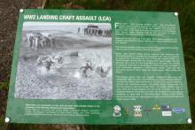 |
|
| 84 |
Borrodale Beach (Road to The Isles) |
A stunning shingle beach with dramtic views over Loch Nan Uamh and the Ardnish peninsula to the hills of Moidart. The beach can be reached either by a short walk from Druimindarrach and combined wiht a visit to Prine Charlie's cave and the old vitrified fort on the other side of the Borrodale Burn. |
| 85 |
Bourblach Beach at Morar (Road to The Isles) |
The beach at BourBlach is particularly lovely at low tide, with its rocky outcrops, surrounded by low, undulating heather-clad hills. |
| 86 |
Camas Ghaoideil (Road to The Isles) |
Camas Ghaoideil is a pebble and shingle beach on the southern shores of the Rhu Peninsula |
| 87 |
Camusdarach Beaches (Road to The Isles) |
A good place for beachcombing, paddling, a picnic or simply counting grains of sand. |
| 88 |
Peanmeanach Beach (Road to The Isles) |
Peanmeanach Beach is a lovely sandy bay at the end of the Ardnish Peninsula |
| 89 |
Rhu Point Beach (Road to The Isles) |
Rhu Point Beach, or Port nam Murrach is a lovely remote sandy cove on the Rhu peninsula, near Arisaig, surrounded by turquoise coastal waters. |
| 90 |
The Silver Sands of Morar (Road to The Isles) |
The Silver Sands of Morar are a stunning string of white sandy beaches just south of Morar on the B8008 |
| 91 |
Traigh Beaches (Road to The Isles) |
The white sandy beaches at Traigh, near Arisaig epitomise the ideal of a West Coast of Scotland beach. |
| 92 |
Lochaber Geopark Hub and Darwin's Rest Coffee Shop (Roy Bridge) |
The Lochaber Geopark Hub and Darwin's Rest Coffee Shop |
| 93 |
Parallel Roads of Glen Roy (Glen Roy) |
The Parallel Roads at Glen Roy consist of a series of parallel horizontal lines on the hill sides of Glen Roy, Glen Goy and Glen Spean. |
| 94 |
Ncn’ean Distillery (Morvern Peninsula) |
Ncn’ean Distillery is a young independent distillery on the Morvern Peninsula offering daily pre-booked distillery tours. |


